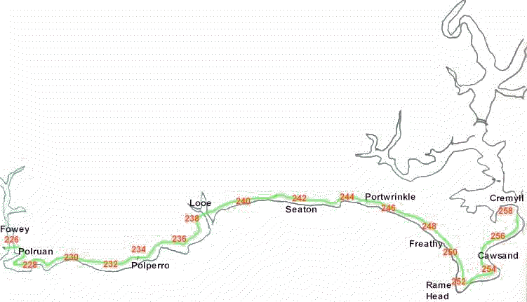
Looe, Cornwall to Plymouth, Devon

Looe Cornwall to Plymouth Devon

miles 238 - 240
Opposite the Guildhall, near the harbour, the path rises steeply up Castle Street, and hence up onto the East Cliff footpath. There are views behind you over the harbour and St George's Island. Ahead you wend through a funny sort of rural suburbia for a mile to reach Millendreath Beach.
Once you clear the chalets of Millendreath, you are back into the real countryside
miles 240 - 242
A steep lane takes the path up the hill and after about half a mile it branches off the road, and back out across open land for another mile and a half, before joining the road again outside Seaton
miles 242 - 244
Down into Seaton, with its grey sand beach and caravan site.There is probably around ten miles to go now when the scenery is not as scenic as it has been. Downderry, another shingle beach is in a mile.
From Downderry follow the road for a quarter of  mile, then across the fields for 3/4 of a mile to re-join the road again
miles 244 - 246
Follow the road for a mile into Portwrinkle, which used to be a fishing port, but now no longer. Again taking the road out of Portwrinkle, the path dives off into the fields after about 400 yards. It crosses edge of the  golf course for a mile
miles 246 - 248
Re-join the road for a mile, to by-pass the army rifle range. Note any warning flags, as they will not let you on the beach during rifle firing.
miles 248 -250
Then there is another mile along the road before you get to the village of Freathy.. Again this piece of coast had many wrecks in times gone by.
Follow the road through Freathy. At low tide you can walk along the beach for two and a half  miles to the end of Whitsand Bay
miles 250 - 252
Walk to the end of the beach if the tide allows. At the end of Whitsand Beach there is a steep path up to the cliff top by an old fort. You get first to Queener Point
miles 252 - 254
From here it is out and round Rame Head, 300 feet high, with great views over Plymouth Sound. The ruined chapel dates back to 1397. Turning back from Rame Head to get to Penlee Point, you pass a coast guard station, and after a mile get to Penlee Point, which has a grottto, a former look out point
miles 254 - 256
From the Grotto on Penlee Point, the coast path follows a made up road through woods for a mile to the twin fishing villages of Cawsand and Kingsand. These were active smuggling ports in their time, being close to Plymouth.
Through Cawsand and past the Sun Inn in Kingsand, a gate takes you onto the Mount Edgcumbe Country Park estate
miles 256 - 258
The remaining two mile to the ferry at Cremyll is through the estate, with views of the house itself. Mount Edgcumbe was destroyed by German bombing during the blitz of Plymouth dockyards in 1941, but it has now been completely rebuilt
From Cremyll there are regular ferry sailings to Plymouth (phone 01 752 822105 for details)

Return to Cornwall Coast Cornwall coast Front Page

Corisande Manor Hotel, Cornwall Corisande Manor Hotel, Newquay, Cornwall - the place to stay to explore the Cornish Coast

Corisande Manor Hotel, Cornwall

And if you want to learn more about Cornwall, then try our Cornish information site, Cornwall Calling

Cornwall map icon Cornwall Tourist Informwtion

Cornwall Coast - your guide to the Cornish Coastal Path