Fowey, Cornwall to Looe, Cornwall
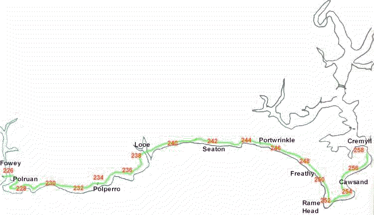
- miles 226 to 228
- Take the passenger ferry to Polruan, where you follow the
quay to the right along the sea. The path goes up Battery Lane. This takes
you round the outside of this small town, and out onto open country after
the car park.
-
-
- miles 228 to 230
- There is some exhilarating walking with a steep climb up
above Bluebottle Rock
- Before dropping to lower cliffs on National Trust land above
Lantic Bay. At the far end of Lantic Bay there is a path up to the Lanteglos
Church (which is a short detour)
- Otherwise continue on the coast path to Pencarrow Head and
round past the old coast guard hut to Lantivet Bay.
-
- miles 230 to 232
- From here the path drops quite steeply down to cross a stream
at West Coombe, a smuggler's cove with sand and rocks
- A track detours right to Lansallos, a hamlet with a 15th
century church
- On the coast path it is another mile to get to yet another
steep down at a stream, followed by a climb to a white navigation marker,
letting ships at sea know of the position of the Udder Rock about a mile off
shore.
- Soon after this you are in for another short sharp descent
to cross a small stream, with another steep climb the other side. taking you
up to the summit of Blackyball Point, with the drop down the other side, with
views of Larrick Rock just off shore.
-
- miles 232 to 234
- A lot of steps lead you up to the cliff tops for a miles
walking along the wide cliffs to Polperro. There are magnificent views along
the coast here.
- Polperro is one of those picture book fishing villages, with
narrow streets and a picturesque harbour crowded in by period houses. At the
height of summer it can be unbearable, but out of season returns to its roots.
- One of those narrow streets at the other side of the harbour
takes you out of Polperro and back onto the cliffs
-
- miles 234 to 236
- The cliff path is well marked and easy to follow, past the
war memorial, and down to Talland Bay, which has a little sandy beach
- Steeply up from Talland Bay, there are two large markers
that delineate one end of a measured nautical mile. Ships can use them to
calibrate their instruments.
- Past the markers, the path continues along the cliffs to
the headland
-
- miles 236 to 238
- On rounding this point you are entering Portnadler Bay. At
the end of the Bay, just before passing the off shore island of St George,
you pass the remains of the Celtic Chapel of Lammanna.
- St George's Island has had a colourful history, being used
by smugglers to store their loot at one time. It was shelled by the German
fleet in World War I, as they mistook it's shape for a lone British Battleship.
It is now a bird sanctuary.
- Arriving at Looe on Marine Drive at Hannifore Point, you
follow the road round to the bridge. Looe was originally two towns, one on
either side of the river, and each town had a medieval charter, and so each
was a Rotten Borough sending two members of parliament each to Westminster,
until the 1832 Act abolished such rotten boroughs.
- Looe is a bustling town in the summer season, but returns
to a quiet place in winter.
Return to Cornwall
Coast Cornwall coast Front Page
Corisande
Manor Hotel, Cornwall Corisande Manor Hotel, Newquay, Cornwall - the place
to stay to explore the Cornish Coast
And if you want to learn more about Cornwall,
then try our Cornish information site, Cornwall Calling

Cornwall Coast - your guide to the Cornish
Coastal Path